
Pilot place biography
Saffuriyya
This record tests the place-biography structure: stable identity, dated observations, attributed events, and traceable sources.
صفّورية · Safuriyya
Non-evidentiary contemporary illustration
Documented snapshot
Estimated population at year-end 1944
4,330Published in the 1944/45 table; extrapolated from the 1931 censusSource · claim-000003
PalQuest reports a population of 4,330 for Saffuriyya in 1944/45.
- Source
- ips-palquest-saffuriyya
- Method caveat
- Key Figures > Population table > 1944/45 row
- Review status
- Research draft
Start of the occupation and displacement phase
16 July 1948Source · claim-000002
The cited locality page records Saffuriyya as depopulated on 16 July 1948.
- Source
- palopenmaps-saffuriyya
- Method caveat
- Key dates section
- Review status
- Research draft
Source · claim-000011
PalQuest describes Saffuriyya's occupation at dawn on 16 July 1948, subsequent returns by some residents, and later expulsions continuing through January 1949.
- Source
- ips-palquest-saffuriyya
- Method caveat
- Occupation and Depopulation section, paragraphs 112–119
- Review status
- Research draft
Life before 1948
This draft brings together the currently documented population, built form, education, and land evidence. Every statement remains a draft claim with a source and exact locator.
PalQuest reports a population of 4,330 for Saffuriyya in 1944/45.
Source · claim-000003
- Source
- ips-palquest-saffuriyya
- Method caveat
- Key Figures > Population table > 1944/45 row
- Review status
- Research draft
The 1944/45 table reports 55,378 dunums in total: 41,748 classified as Arab-owned and 13,630 as public land.
Source · claim-000004
- Source
- ips-palquest-saffuriyya
- Method caveat
- Key Figures > Land Ownership, 1944/45 table
- Review status
- Research draft
PalQuest reports 747 houses in Saffuriyya in 1931.
Source · claim-000005
- Source
- ips-palquest-saffuriyya
- Method caveat
- Overview section > settlement morphology paragraph
- Review status
- Research draft
The profile describes cement and mud houses arranged in a rectangular grid, with streets meeting at the commercial centre.
Source · claim-000006
- Source
- ips-palquest-saffuriyya
- Method caveat
- Overview section > settlement morphology paragraph
- Review status
- Research draft
The profile reports two elementary schools in Saffuriyya and dates the founding of the boys’ school to 1900.
Source · claim-000007
- Source
- ips-palquest-saffuriyya
- Method caveat
- Overview section > education paragraph
- Review status
- Research draft
For 1944/45 the profile reports 21,841 dunums in cereals, 5,310 in plantations and irrigable land, and 3,720 planted with olives.
Source · claim-000008
- Source
- ips-palquest-saffuriyya
- Method caveat
- Overview > agriculture; Key Figures > Land Use table
- Review status
- Research draft
The profile places Saffuriyya in the Nazareth subdistrict of Galilee.
Source · claim-000009
- Source
- ips-palquest-saffuriyya
- Method caveat
- Header and Key Figures > Geographical Location
- Review status
- Research draft
Location and landscape
Present context, not historical evidence
Saffuriyya in the present-day landscape
An approximate present-day locality point. It is not a historical boundary, building plan, or proof of the position of every part of the village.
- Coordinates
- 32.7524, 35.2781
- Precision
- Approximate locality point
- Map state date
- Present-day map context accessed 23 July 2026. Individual map features have varying update dates.
- Claim ID
- claim-000010
Evidence boundaries
What do we know, and what remains unknown?
This panel separates historical records, present-day context, and visual interpretation. “Documented” does not mean that the record has completed final named human review.
Registered to a specific source
- A population of 4,330 in the 1944/45 table, retaining the note that it is a year-end 1944 estimate rather than a new census.
- 747 houses in 1931, plus bounded descriptions of settlement form, education, and land use.
- Three July 1940 photographs reviewed by the project for item-level display rights.
- An approximate present-day locality point, registered for context only.
Unresolved or unavailable
- A precise historical village boundary, street alignments, and building footprints.
- A rights-reviewed historical aerial frame suitable as a spatial reference.
- Named human factual, Arabic, and English review.
- An architectural or spatial reconstruction that can be treated as evidence.
Use readiness
| Path | State | What it means |
|---|---|---|
| Archival image room | Documented | Three items with source attribution and rights advisory. |
| Life-before-1948 biography | Draft | Claim-backed and awaiting independent human review. |
| Present-day map | Context | Approximate point; not historical geometry. |
| Visual reconstruction | Interpretation | Generated and persistently labelled; not evidence. |
| Precise aerial reconstruction | Blocked | Requires a usable historical aerial frame and verified rights. |
Saffuriyya across time
A sourced chronology presents Saffuriyya before the Nakba as a place shaped by centuries of life and change, then shows uprooting as a rupture in that history rather than the story’s beginning. Every stop links to a registered claim and exact source locator.
- to the 18th c.Historical layersA regional centre, political transitions, and landmarks retained in place memory.
- 1900–1945Life and institutionsEducation, local administration, built form, agriculture, and sourced population snapshots.
- 1948–1949Uprooting and aftermathOccupation, flight, partial return, and later expulsions.
- Roman–ByzantineDocumented
A regional centre in a long history
The source places Saffuriyya at a gateway to Lower Galilee, describes its role as an administrative centre after the Roman conquest, and notes Jewish and Christian communities in the Byzantine period.
Source · claim-000012
- Source
- ips-palquest-saffuriyya
- Method caveat
- Village Before 1948 > geography, Roman, and Byzantine history paragraphs
- Review status
- Research draft
- 634 / 1187Documented
Muslim conquest and medieval transitions
The source records the Muslim conquest in 634, later Crusader castle-building, and Salah al-Din’s recovery of the town after the Battle of Hittin in 1187.
Source · claim-000013
- Source
- ips-palquest-saffuriyya
- Method caveat
- Village Before 1948 > Muslim conquest and Crusader-period paragraph
- Review status
- Research draft
- Documented
An Ottoman demographic and agricultural snapshot
The profile reports 2,200 people and connects the snapshot to taxes on wheat, barley, olives, and other produce. The figure is retained as the source reports it, not presented as a modern census.
Source · claim-000014
- Source
- ips-palquest-saffuriyya
- Method caveat
- Village Before 1948 > 1596 Ottoman register paragraph
- Review status
- Research draft
- Documented
Zahir al-Umar’s hilltop fortress
The source records Zahir al-Umar al-Zaydani’s construction of a fortress on the hilltop above Saffuriyya, a built milestone kept distinct from the village’s later layers.
Source · claim-000015
- Source
- ips-palquest-saffuriyya
- Method caveat
- Village Before 1948 > Zahir al-Umar and fortress paragraph
- Review status
- Research draft
- 1900–1923Documented
Education and local administration
The profile dates the boys’ school to 1900 within a two-school elementary system, followed by the establishment of a local council in 1923.
Source · claim-000007
- Source
- ips-palquest-saffuriyya
- Method caveat
- Overview section > education paragraph
- Review status
- Research draft
Source · claim-000016
- Source
- ips-palquest-saffuriyya
- Method caveat
- Village Before 1948 > modern village and institutions paragraph
- Review status
- Research draft
- Documented
3,147 people and 747 houses
The population table records 3,147 people, with a footnote including Arab al-Hujayrat and Arab al-Hajajira, while the settlement profile reports 747 houses. The house count is not treated as households or surviving buildings.
Source · claim-000017
- Source
- ips-palquest-saffuriyya
- Method caveat
- Key Figures > Population table > 1931 row and footnote
- Review status
- Research draft
Source · claim-000005
- Source
- ips-palquest-saffuriyya
- Method caveat
- Overview section > settlement morphology paragraph
- Review status
- Research draft
- 1944/45DocumentedLast documented population snapshot before the Nakba
The last documented population snapshot before the Nakba
The profile records 4,330 people alongside 21,841 dunums in cereals and 5,310 in plantations and irrigable land, including 3,720 planted with olives. The population figure is a year-end 1944 estimate derived from the 1931 census, not a new 1945 census.
Source · claim-000003
- Source
- ips-palquest-saffuriyya
- Method caveat
- Key Figures > Population table > 1944/45 row
- Review status
- Research draft
Source · claim-000008
- Source
- ips-palquest-saffuriyya
- Method caveat
- Overview > agriculture; Key Figures > Land Use table
- Review status
- Research draft
- Documented
The beginning of occupation and uprooting
Palestine Open Maps records this depopulation date, while PalQuest describes occupation at dawn and the beginning of a process of flight, partial return, and later expulsion. The date is therefore not presented as the process’s single endpoint.
Source · claim-000002
- Source
- palopenmaps-saffuriyya
- Method caveat
- Key dates section
- Review status
- Research draft
Source · claim-000011
- Source
- ips-palquest-saffuriyya
- Method caveat
- Occupation and Depopulation section, paragraphs 112–119
- Review status
- Research draft
- Documented
Expulsion continued after partial return
PalQuest describes some residents returning after July 1948, followed by later expulsions that continued through January 1949.
Source · claim-000011
- Source
- ips-palquest-saffuriyya
- Method caveat
- Occupation and Depopulation section, paragraphs 112–119
- Review status
- Research draft
3 project rights-reviewed items
The village image archive
Three Matson Photo Service photographs from July 1940 passed project item-level rights review. Each retains its date, identifier, and Library of Congress advisory; the advisory is not a copyright warranty.
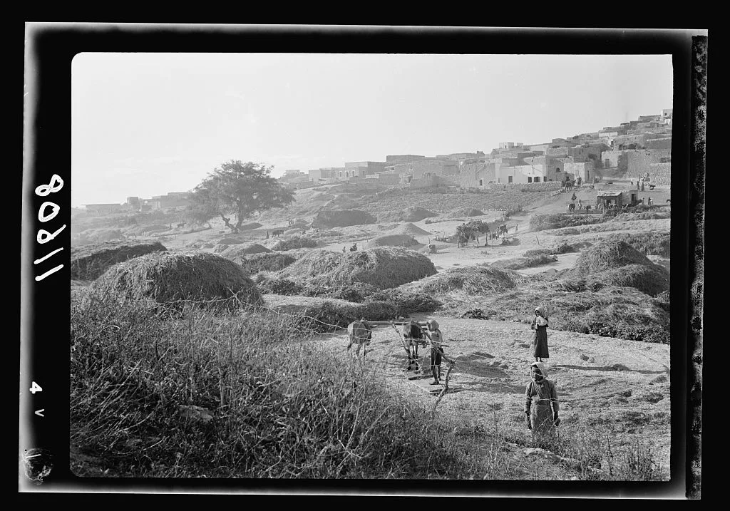
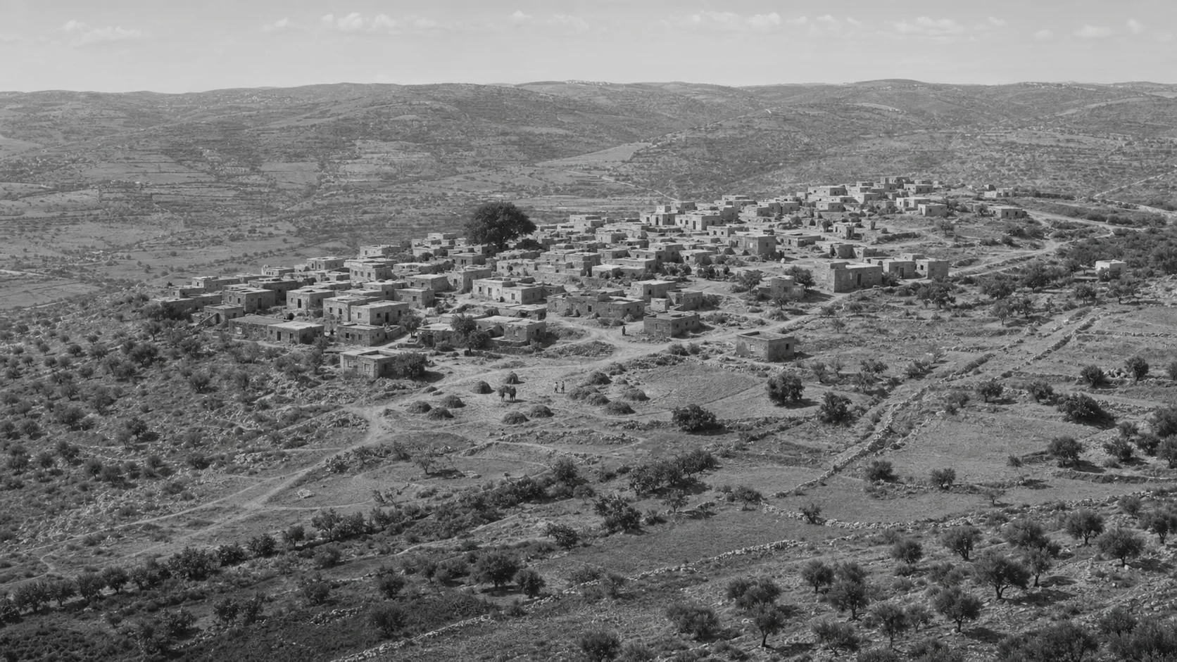
Threshing floors below the village
General view of Saffuriyya’s threshing floors below the village, with the village houses on the hillside.
Documented archival view; a promising wide-view reference, but insufficient for reconstruction.
Item advisory: no known restrictions on publication
Open the Library of Congress item record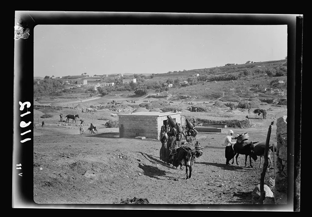
Water-distribution station
Saffuriyya’s water-distribution station in open land, with people, animals, and tracks nearby.
Archival evidence of water infrastructure and everyday activity; partial street-scale reference.
Item advisory: no known restrictions on publication
Open the Library of Congress item record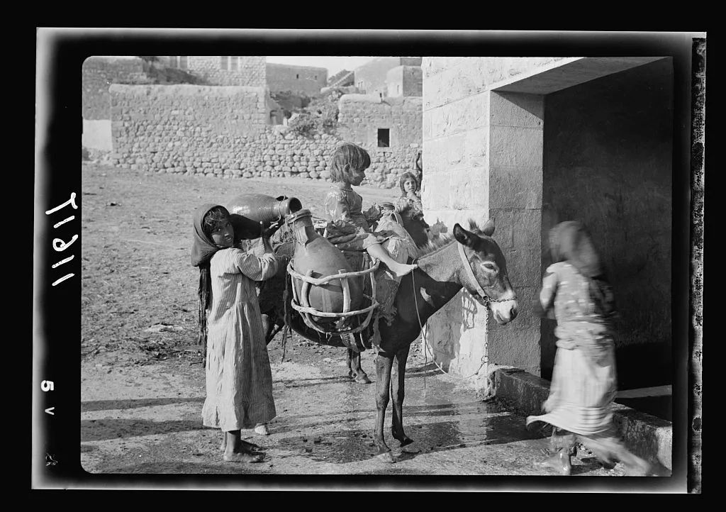
A water-fetching scene
A scene at the water source. The Library record describes a village girl carrying water jars on a donkey.
Documented everyday-life and built-context view; the person’s identity is not inferred.
Item advisory: no known restrictions on publication
Open the Library of Congress item recordDo you hold a photograph of Saffuriyya?
We are preparing a contribution path that protects ownership, consent, and privacy. Files are not accepted in this edition, but you can review what will be required.
First visual study · generated interpretation
If the village had continued
A work-in-progress lab for comparing what can be documented before 1948, what remains today, and a source-bounded alternative future.
First visual study · generated interpretation
The interface separates archival images from generated interpretation and future scenario. No scene reconstructs one specific building or proves a route or boundary.
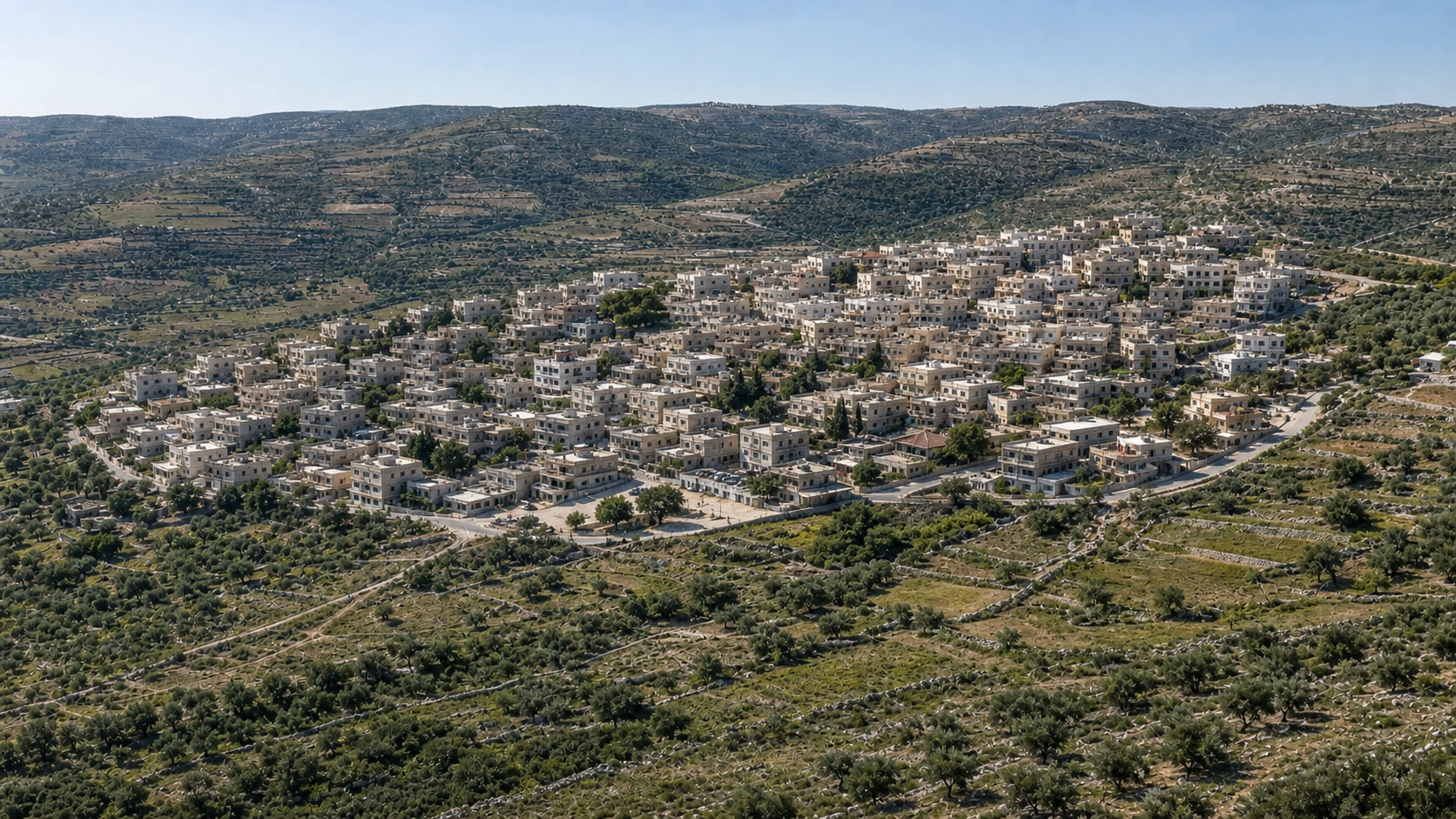 Generated image · conditional scenarioConnected-town scenario · 2026
 Generated bird’s-eye visual hypothesis · circa 1940–1945Interpretation around 1940
A generated bird’s-eye hypothesis based on the 1940 landscape view, documented settlement form, and land use; no verified historical aerial photograph is registered.
A comparison between two generated views with a similar composition—not a repeat photograph of the same viewpoint.
Drag the handle on the image to compare. Use the arrow keys for precise control.
No verified aerial photograph of Saffuriyya is registered. This view draws on the 1940 landscape photograph, the documented settlement description, and aggregate land-use data; building, road, and field locations are hypothetical.
Interpretation references: 1940 threshing-floor view, documented settlement form, and aggregate land-use data; no verified historical aerial reference.Conditional demographic interpretation
How large might the population have been in 2026?
Counterfactual present · 2026
Three counterfactual-present calculations start from the documented 4,330 value for 1944/45. They differ by growth assumption, not by confidence level.
A middle path in which Saffuriyya grows into a town connected to Nazareth with an active local centre.
- Annual growth assumption, 1945 to 2026
- 2.2%
- Range across scenarios
- 15,70032,000
First visual-study queue
Ten places are candidates for source scanning only. Reconstruction starts only after rights and evidence review for every angle.
- 01
Iqrit
Early research
- 02
al-Bassa
Early research
- 03
Lubya
Early research
- 04
Safsaf
Early research
- 05
Deir Yassin
Early research
- 06
Tantura
Early research
- 07
al-Majdal
Early research
Limits of this record
The current source permits limited factual citation only. This page is not a precedent for bulk ingestion or republication of text and images.
Review sourcesReview path
- Factual review: not started
- Rights review: pending
- Arabic review: not started
- English review: not started
- Map review: awaiting sourced geometry